
Interestingly, academics often trace the very origins of geographic information systems (GIS) to the beginnings of epidemiology and John Snow’s Cholera map of 18541.
Globally, the COVID-19 outbreak is demonstrating, in almost real-time, how individual countries, such as Italy, must respond to a truly national emergency.
With the exception of the ebola outbreak in recent times, mobilisation and response to an emergency situation at a truly national level has probably not been widely experienced since WW2.
It’s also showing that, for containment and quarantine to be optimally effective, then response must be administered at a national level.
The current situation with the COVID-19 outbreak is bringing into sharp focus how and when a truly fit-for-purpose national Emergency Management database might be required to enable planning and responding at scale.
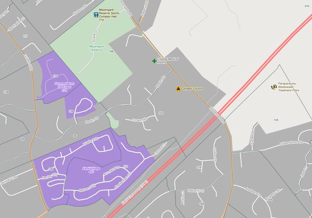
NationalMap’s Emergency Management Basemap (EM Basemap) was designed and built specifically for application at a nationwide level, and is provided to all non-commercial users at no cost, in the interests of making our country more resilient. The basemap is made freely available by NationalMap and published on data.govt.nz2 by Land Information New Zealand.
NationalMap’s EM Basemap is an OGC-compliant Web Map Service (WMS) that includes reference data specifically collated for New Zealand’s emergency services and managers.
The data content is standardised and consistent across New Zealand, providing familiarity with the Basemap regardless of the incident or responder locations and is immediately accessible through your GIS, or web browser.
EM Basemap provides population and occupancy figures for:
- 2018 census population figures for Territorial Authorities, and Statistical Areas 1 & 2
- Hospitals (Private and Public, with A&E facilities uniquely symbolised)
- Schools
- Retirement Villages/Rest Homes
- Major Event Centres
- Prisons.
As well as detailed location data for:
- Fuel Supplies
- Supermarkets
- Retail Centres
- Emergency Services (FENZ/Police/Ambulance)
- Medical Centres
- Early Childhood Centres
- Tertiary Campuses
- Retirement Villages/Rest Homes.
The latest product releases of EM Basemap include:
- A full review of Civil Defence Centres (823 total)
- A full review of Medical/General Practice POI’s (1184 total)
- A full review of the Emergency Services POI’s including:
- FENZ (664)
- Police (300)
- Ambulance (220).
We’ve spent years preparing, enhancing and managing a truly fit for purpose national emergency dataset that’s ready to use right now.
If your current data or basemaps are causing you concern when applied at a national level, then we want to help you do your job with the assurance that data is not hampering your efforts.
If you’re working as one of our incredible first responders, or public sector agencies (or anyone looking to help), then I urge you to get in touch – this is exactly what we built EM Basemap for.
1 https://en.wikipedia.org/wiki/1854_Broad_Street_cholera_outbreak
2 https://catalogue.data.govt.nz/dataset/emergency-management-basemap