
Ever feel that everything moves a little too slowly in your sleepy little home-town? Do you long for the fast pace of the big city?
Well, you’re probably not alone there, particularly if you’re young. In fact, there’s essentially a whole genre of rock music dedicated to articulating the spirit of restless youth yearning to be free of the shackles of their small-town upbringing (and escape to the big smoke…).
In many instances of course the pace of life in big cities IS very different to our small and regional towns, there’s more to see and experience and it’s only natural for young people to crave a bit of excitement.
However, when it comes to traffic, road speeds and drive times, our big cities can’t really be described as “fast-paced”.
Sadly, it might be a bit of shock to our young rock and roll dreamers that the fast, open roads of their small home-town surrounds actually morph into a vast network of low speed, congested streets as you enter the big city proper.
While it is a pretty reliable rule that the more built up a town or city is, the more likely it is to have a larger number of roads with low speed limits, there are also factors other than infrastructure and population density at play when it comes to road speed limits.
Topography is an obvious one, Wellington’s hills and geography mean road speeds there are likely to be set lower than the less vertiginous Auckland for example.
But irrespective of whether a road is in a built-up urban area, or in a less populated rural area, “driving to the conditions” often means driving slower than the speed limit anyway (due to factors such as surface type/condition and whether a road is straight or full of bends).
In reality then, there’s always two speeds for any road (well at least for those of us who choose to drive carefully) and they are the legal speed limit and the speed you can actually (safely) travel.
Legal speed limit versus the likely actual speed limit (or routing speed)
Probably the most popular application of NationalMap’s Roads data is for routing purposes, our customers trust it as the most up to date and comprehensive data source available when it comes to navigating New Zealand’s roads.
This is why the NationalMap’s “routing speed” data layer is so important, because it enhances real-world route planning for optimal efficiency and is the actual speed, in km/h, that could be expected for travel on a road link. It’s a calculated field and considers speed limit, surface type, hierarchy, bendiness as well as access restrictions.
So, if we are to do some analysis on what are the fastest or slowest towns or areas in New Zealand, it’s important to keep those two measures in mind – legal speed and routing speed.
Worth noting too, that for all the following data and analysis we’ve defined a built-up area or towns as being greater than 3km2. We have also excluded motorways, as these tend to artificially distort speeds for the defined areas and are almost always effectively separate to the town’s road network.
How to define what is a “fast town” and a “slow town”
As you’d probably expect, many towns and areas in New Zealand are comprised solely of roads that are set at a legal speed limit of 50km or lower. However, quite a few towns contain a not insignificant number of roads where the legal speed limit is over 50km too, so in theory at least, getting around them should be quicker (than towns where all the roads are set at 50km or less).
Here then are New Zealand’s “fastest towns” purely on the basis of the percentage of roads that are set at a speed limit of over 50km:
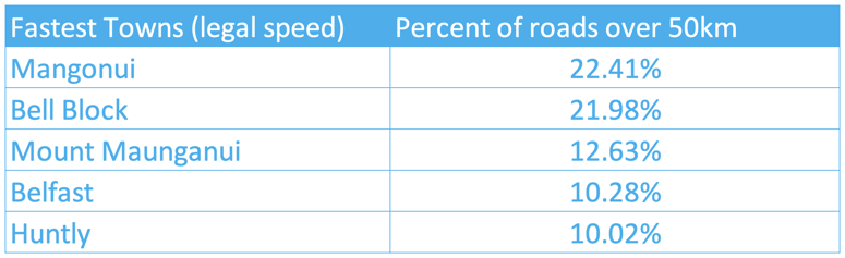
While it may be no surprise to residents of Mangonui that on nearly 25% of their roads you can legally drive over 50km per hour, I’m fairly certain holiday visitors to Mount Maunganui will be pondering quite how “The Mount” makes it into this list of “fastest towns”…
But of course that is because the above table is for percentage of roads with a legal speed of 50km and over, and not routing or actual speed.
Some towns though are just bigger than others and some road sections are longer than others, so perhaps a percentage of roads over 50km measure is not properly reflective of reality? Perhaps a better representation of how quickly (or slowly) you could get around a particular town would be a measure of “mean legal speed in km”?
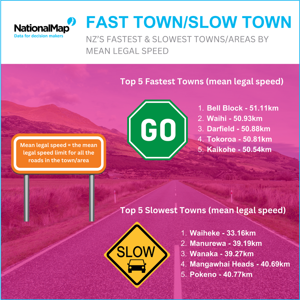
Here’s New Zealand’s fastest and slowest towns on the basis of “mean legal speed in km”:
But again, theory and reality are bumping up against each other here, because as discussed earlier, a road’s legal speed limit being set at 50km, does not necessarily mean you can ACTUALLY drive 50km on it, safely or otherwise.
Let’s see what the fastest and slowest towns in New Zealand are using NationalMap’s Roads routing speed measure and the “mean routing speed in km”:
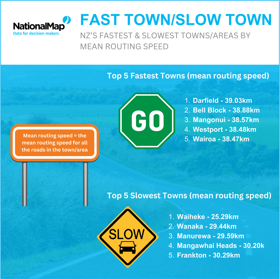
You’ll note from the above infographics that the mean routing speeds are significantly lower than the mean legal speeds. Looking more closely at the top 5 fastest towns across both the mean legal speed and mean routing speed graphics, you’ll note that only 2 of the same towns/areas feature across both measures (Darfield and Bell Block). This variance in who makes the top 5 fastest towns for legal and then for routing speed just reinforces the case for an accurate estimation of journey time based on reality (routing speed) and not theory (legal speed).
Interestingly though, you’ll also see that when it comes to the slowest towns in New Zealand, the towns/areas in the top 5 remain largely the same across both mean legal and mean routing speed measures (ie. Mangawhai Heads, Wanaka, Manurewa and Waiheke feature in the top 5 for both measures when it comes to slow towns).
This is because the relationship between “mean legal speed” and “mean routing speed” becomes more tightly related at lower speeds and largely explains why 4 out of 5 of the slowest towns are the same for both legal and routing mean speed measures.
Scale matters too, for example, given the area, length and complexity of Manurewa’s road network (with a mean routing speed of just 29.59km) it’s still likely to take you longer to transit through Manurewa than Waiheke (with a mean routing speed of 25.29).
What about our biggest cities? Well, as you’d expect they are amongst the slowest towns/areas in the country, and while some of the above smaller towns may beat them for mean slowness (as dense little pockets of low speed) the much larger catchment areas of the big cities slow down traffic far more expansively.
Mean routing speed of our major cities
- Christchurch – 35.69 km/h
- Wellington – 35.34 km/h
- Auckland – 34.12 km/h
When you take into consideration the scale and sprawl of our main cities, maybe the fast, easily accessible open roads surrounding your small home-town don’t look so bad after all?
But whichever way you look our slowest towns/areas, if you’ve just bought a new sports car, it’s safe to say that Waiheke Island is not the place to day trip to and hit the open roads with the pedal to the metal… which brings me to another point.
You’d probably be amazed at the number of metal (gravel) roads that have alarmingly high “legal” speed limits where it’s quite obviously unsafe (if not down-right impossible) to actually go the “legal speed”. This is where the road surface component of the NationalMap roads dataset properly comes into play for rural transport operators in particular. There will be a whole blog dedicated this specific topic coming soon - so stay tuned.
Anyway, the truth is, what looks like the fastest route in theory often isn’t in reality.
And if you’re a commercial transport operator it REALLY pays to get routing and navigation right, because at scale, small inefficiencies all compound adding up to significant cost and wasted resources.
Luckily, NationalMap have been helping New Zealand businesses optimise their routing and navigation for over 30 years, so get in touch with us today if you want to understand how NationalMap Roading data and solutions can help your business or organisation.