
It’s been well over a month since speed limits were slashed on more than 600 Auckland roads, with Auckland Transport saying their data shows journey times have barely changed in that time, largely (they say) because travel speeds were already below the new speed limits.
The speed limit cuts were brought in with the aim of reducing deaths or serious injuries which is of course highly desirable, and when localised speed reductions in past years have been shown to boost safety, it makes a lot of sense.
So, all well and good in that respect, however, Auckland Transport also surveyed drivers after the changes came into effect and found that more than half of respondents felt that their travel time had increased.
Clearly there are always trade-offs in any situation like this and while most of us would probably lean towards a safety first approach, the logistical and economic impacts need to be considered too.
Changes in road speed limits (among other changes and additions to the road network) can have a huge impact on distribution, logistics and transport businesses. Cumulatively, if not effectively managed, these changes can run into hundreds of thousands of dollars annually in lost productivity, additional fuel and other associated costs.
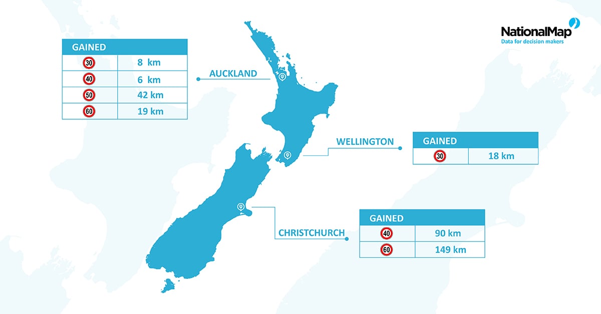
Indeed if you look at the infographic above, then you can see it is not only Auckland that has been affected recently by significant changes to road speed limits. Since May 2020, Christchurch has seen a huge change in speed limits around the city (gaining nearly 149km of roads where the speed limit was reduced to 60km per hour). This will undoubtedly have an impact on journey times and productivity, unless actively mitigated where possible through smart routing solutions.
Here at NationalMap, we maintain the most up-to-date and comprehensive road and transport dataset available in New Zealand, and we are constantly improving and refreshing this information with the very latest data. In fact, you can check out our latest work on updating speed limits here in our September 2020 NationalMap release notes.
NationalMap provides users with a fully navigable road network, with a wide range of attribute data that gives them the ability to customise calculations, plan their routes based on the very latest information, and then output down to the finest detail.
Of course speed limit data is just the tip of the iceberg, our Road & Transport dataset also includes; access named roads, new roads added, carriageways, turn restrictions, one-way indicators, travel speed categories, surface type, legality, pedestrian and cycle networks, bridges, publicly and privately-maintained roads, railways, ferry routes, airports, points of interest, and much, much more.
So, if you need to optimise your freight, distribution and logistics business with the best roading and routing data available, then get in touch with us today.