
For the third blog in our series on the relationship between people and their proximity to amenities (for which we use one or more of our extensive points of interest POI data sets) we have focused on fast-food or “quick service restaurants”.
An overheard conversation the other day around “why fast-food joints are always in the less salubrious parts of town” got me thinking - are they really?Now, most of us probably have a soft spot for one kind of fast-food or another (I personally have a particular weakness for fried chicken) but whether it’s fried chicken, burgers or pizza is a simply a matter of personal taste.
Or is it?
A lot of research here in New Zealand and internationally DOES suggest that there is a strong association between neighborhood deprivation and the location of, or access to, fast-food outlets.
So maybe your “choices” are also influenced by your location?
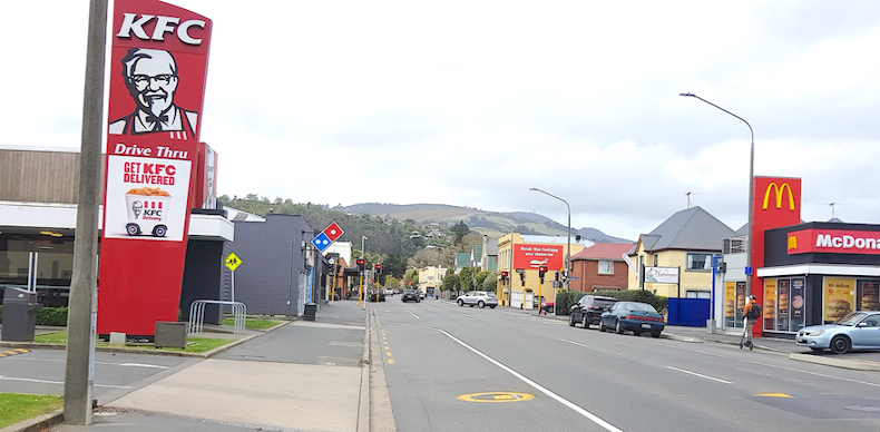
For example, if you’ve got a hankering for KFC for lunch but you know that the closest outlet is miles away from the office, you may have to settle for that local salad bar you like instead, because you can get there and back in your lunch break no problem.
At NationalMap, we think about location ALL THE TIME so these kinds of questions fill our day.
Thankfully NationalMap’s “Points Of Interest (POI)” database can often help validate or illuminate our own or customer questions and hypotheses.
In this instance, we mapped our fast-food or “Quick Service Restaurants” database against the New Zealand Deprivation Index to see if we could find some answers.
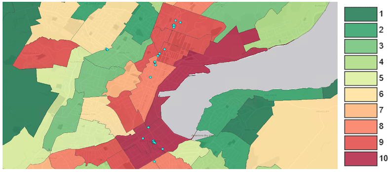
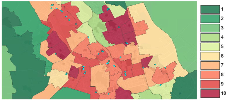
The New Zealand Deprivation Index is essentially a scale of deprivation that categorises New Zealand statistical areas into a 10 point scale with 1 (green) denoting least deprived and 10 most deprived (red).
Using the New Zealand Deprivation Index analysis (derived from the 2018 census) and NationalMap’s POI data to show fast-food outlets, there does seem to be a strong correlation between high deprivation areas and the volume of fast-food outlets.
The data clearly show that the majority of fast-food outlets are located in more deprived areas, with over 50% of outlets located in the highest 8-10 Deprivation Index areas.
Below you can see just a couple of examples of where fast-food outlets are located in Hamilton and Dunedin.
Dunedin – location of fast-food outlets within deprivation index areas
Hamilton - location of fast-food outlets within deprivation index areas
So, are fast-food chains really just targeting poorer, more deprived areas?
When it comes to choosing the ideal location restaurant owners should consider the following factors according to EHL – The World's Leading Hospitality University:
- Demographics
- Visibility
- Accessibility
- Competition
- Safety and crime data
- Proximity to suppliers
- Size and space requirements
- Zoning regulations
- Affordability
EHL make the point that when considering demographics it doesn’t make much sense to open a steakhouse in an area you know has a high level of health-conscious vegetarians. Nor would you open your pricey steakhouse establishment right next to the city’s main university campus for reasons related to disposable income (or lack thereof).
EHL’s list above helps illuminate that while socioeconomic demographics are clearly important, most fast-food operators need to consider a whole range of other location-based factors in addition. It is probably a little unfair then that they are so often accused of just placing outlets in high deprivation areas as their sole strategy.
For example, while CBD locations do tend to be in high deprivation areas, choosing CBD locations for restaurant locations ticks off a number of other factors listed above, as you'll need a space that is zoned commercially (rather than residentially) and ideally in a highly visible and easily accessibly spot for maximum car & foot traffic.
In addition, like all business owners (where they can avoid it) restaurant operators don’t want to operate in an area with a high crime rate, as people who may otherwise visit may stay away due to fears over their safety.
As with most things in life then, the picture is a little more complex than at first glance and correlation does not equal causation as we all know!
Being located for maximum visibility and accessibility
It seems being optimally located is a key driver for fast-food outlets, so we decided to do some more analysis using NationalMap’s Roads database.
NationalMap’s extensive Roads database uses a hierarchy, which is a structured network of roads (road segments) that have been grouped and graded by importance:
- Motorway
- Principal
- Connector
- Local
- Forestry
- Service Lane
- Walkway/Accessway
If we exclude irrelevant categories (for this purpose) such as Motorway, Forestry, Service Lane, Walkway/Accessway and focus on the Principal, Connector and Local categories then we find that 46% of all fast-food restaurants in New Zealand are located on Principal Roads (when Principal Roads only make up 10% of the total road network in New Zealand).
After Motorways, Principal Roads are the busiest, most important roads in the country – these are not the quiet leafy streets of suburbia.
Principal Roads are more likely to be in high deprivation index areas (or vice versa) because residential buildings and neighbourhoods simply don’t tend to be built on, or right next to main arterial (Principal) roads.
Which is to say that, it’s at least feasible that fast-food outlets are simply focusing their locations on roads that provide the greatest visibility, access and traffic opportunities – critical when your business model relies on selling quickly in high volume.
This is also probably why we tend to see fast food restaurants cluster together. You’ve probably observed this yourself, but it is also backed up by the data in NationalMap’s POI database.
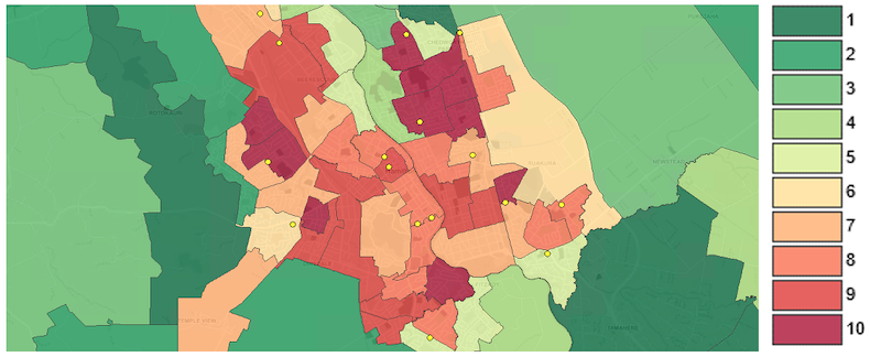
Finally, no one regularly accuses supermarkets of targeting poorer communities (in terms of their store locations) but supermarkets in New Zealand are often located similarly to fast-food outlets in higher deprivation index areas AND ON PRINCIPAL ROADS - as you can see from the below map graphic.
Hamilton - location of supermarket stores within deprivation index areas
The beauty of visualising rich geospatial data sets is that new insights can be discovered and derived that help businesses gain competitive advantage and better illuminate the world around us.
So, next time you fancy a burger or a bucket of chicken (regardless of the other factors involved in the site selection by the franchise) you’ll no doubt be pleased that your favourite fast-food joint is likely to be easy to find, easy to get to and has plenty of parking.
Indeed, perhaps those factors were the key considerations as to where the franchise chose to locate their outlet – (fast) food for thought anyway.
If your business or organisation could benefit from the rich insights that NationalMap and its POI data can provide, please feel welcome to get in touch and discuss your requirements.