
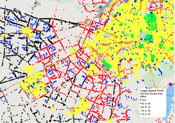
Visual of the western greater Christchurch area showing legal speed limits and the houses they impact.
There’s a plethora of data available online for home buyers these days. From aspects like sunshine hours and commute distance, to the availability of fibre broadband locally.However, a quick scan over the usual property information websites used by those browsing for property indicates that there’s still a few missing pieces of the puzzle (as far as this humble data scientist is concerned anyway).
Now, I don’t know about you, but I’m a nature guy and I like peace and tranquillity. It’s one of the main reasons why I choose to live in the beautiful Kāpiti coast. The buzz and pace of the city is not for me and I definitely don’t want to live somewhere there are hundreds of cars whizzing past my front door (at speed) every day.
I know I’m not alone in this preference, you just have to look at the enduring popularity of “lifestyle blocks” to see that getting away from noise, pollution and the rat-race are common desires.
So, it was with some surprise that in the course of a project myself and the rest of the NationalMap team were working on that we came across the insight that quite so many New Zealand homes are located on roads that have a speed designation of 70km per hour or higher.
In fact, when we created a dataset and visualisation by joining our Comprehensive National Address Register (CNAR) data with the speed limits data from NationalMap, we found that 272,398 homes are located on roads with a speed limit in excess of 70km per hour.
Now, as we all know, there are significant safety issues related to car speed (it’s why speed limits around schools are always so reduced) so it makes sense for this to be a consideration for homebuyers – particularly those with young children.
In addition to increased traffic safety concerns, there are also noise and air pollution considerations for people living on these higher speed (70km per hour or over) designated roads.
While it may seem obvious that there is a relationship between number of houses on a road and the speed limits on that road (ie. more houses the lower the speed limit) often that change can happen incrementally. In fact, unless a road is planned and built as part of a planned new development (which is all largely built at once) then incremental change is the norm.
In this this example below a significant number of new houses have been added on the route north out of Featherston in the last couple of years.
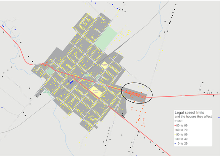
For those not familiar, Featherston is a small rural town in the Wairarapa and for decades this stretch of road on the way out has been 70km (because there was little to no residential housing on it). With property prices in nearby Wellington increasingly steeply, more and more people are looking to buy more affordable homes in commutable zones (like Featherston). It is highly likely that (having seen this many times over the years) this stretch of road will soon be designated a 50km zone due to this extensive new housing.
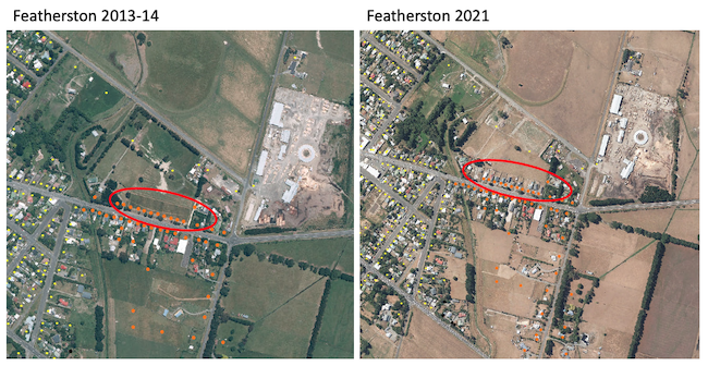
Aerial views of Featherston showing the construction of a significant number of houses on the road north in just a few years.
For my money, assigned road speed (and maybe a related calculation of likely pollution levels - both noise and air quality) would be a valuable addition to the information presented by the property information portals. This data is probably something insurers would have an interest in too (with regard to the “insured vehicle home address” as an input for their actuarial calculations for auto insurance).
Either way, if your business is looking for powerful address-level geospatial or roading data insights, then get in touch with the team today to have chat about how NationalMap data can add value to your products and services.