

A proposed housing development south of Auckland got me thinking about the location of new housing
My expertise is mapping…..mapping the above ground, or ‘viewable world’, but there is a whole other world in underground services, which is vital to our everyday as we know it.
It was with some interest then that I spotted two new proposed subdivisions that were publicised in the media recently.
Both are sizable (several hundred new homes), but in completely different regions (one in Havelock North and one South of Drury).
One article spoke of the ‘strain’ it would put on local infrastructure, yet it appears to have many schools, shops/shopping and medical centres in close proximity. The other development south of Drury (albeit next to the motorway) has only one local primary school and is possibly twice as big as the development in Havelock North which means a total reliance on motor vehicles for everyday life.
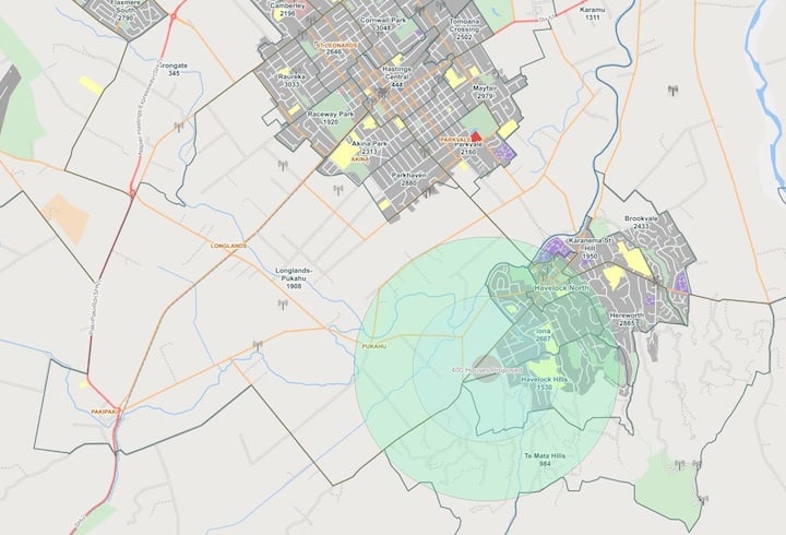
NationalMap shows that there's plenty of infrastructure and amenities close to the proposed housing development in Havelock North.
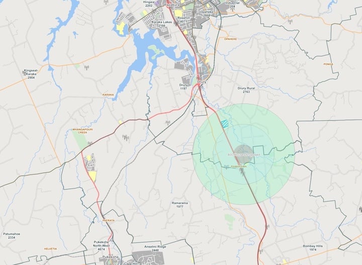
NationalMap also shows that there is precious little in the way of infrastructure and amenities close to the proposed housing development south of Drury.
For me it’s about knowing where the new roads, schools, shops, or essential services like doctors are, so I can ‘include’ them and make them ‘live’ in NationalMap at the correct time. But as one of the articles spoke of the ‘strain’, it got me thinking about the ‘unseen’ and the planning and coordination that goes on behind the scenes.
There is a lot to consider.
Councils and other service providers are constantly reviewing the ‘cost to benefit ratio’ of making land available for housing developments.
Roading, water, sewerage, power, rubbish collection and telecoms (not many people like to be without the internet or phone signal), all play their part, but what about how many more students local schools can take? Or how will 400/1000/2000 extra cars effect the roads in the area?
The questions are continuous and not my realm of expertise, but it has given me a new respect for all those involved in the urban planning process who do try to answer every question before developments go ahead.
Looking at our NationalMap EM/Infrastructure basemap, it was quickly obvious how accessible local amenities are for these proposed subdivisions and it even includes detail down to school roll numbers and suburb population.
You can make sure you always know “where it’s at” with NationalMap data – if you need to improve your business decisions and outcomes then get in touch with us today.